


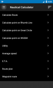


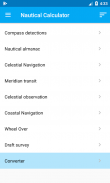
Nautical Calculator
คำอธิบายของNautical Calculator
Nautical Calculator เป็นแอปพลิเคชั่น Android ที่คำนวณเส้น rhumb และการนำทางเป็นวงกลมที่ยอดเยี่ยม
แอปพลิเคชั่นนี้ฟรีทั้งหมด
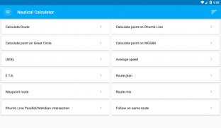
หน้าที่หลักคือ:
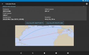
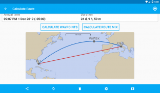
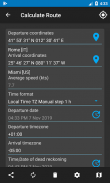
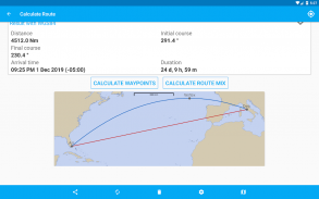
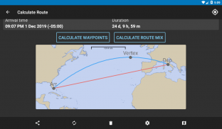
- ให้พิกัดสองพิกัด หลักสูตรวงกลมใหญ่และเส้นรูปสี่เหลี่ยมขนมเปียกปูน ระยะทาง จุดยอดวงกลมใหญ่ และเส้นเมอริเดียนคำนวณ เป็นการแสดงกราฟิก
- เมื่อได้รับตำแหน่ง ตำแหน่งใหม่จะถูกกำหนดโดยการเลื่อนตำแหน่งสำหรับหลักสูตรและระยะทาง
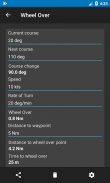
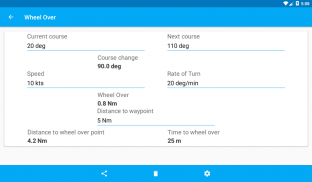
- การคำนวณวงล้อ
- การตรวจจับเข็มทิศ
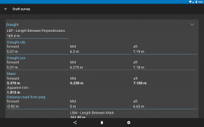
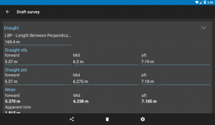
- ร่างแบบสำรวจ
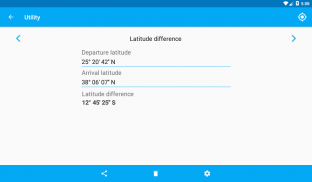
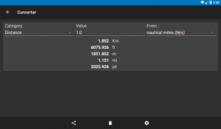
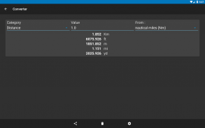
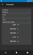
- ตัวแปลง
- คุณประโยชน์
สามารถเปิดใช้งานคุณสมบัติอื่น ๆ ได้
- คำนวณความเร็วเฉลี่ย
- อี.ที.เอ. การคำนวณ
- แผนเส้นทางสำหรับการวางแผนจุดอ้างอิงด้วยตนเอง
- เส้นทางเวย์พอยท์
- เส้นทางผสมกับขีด จำกัด ขนาน
- Rhumb Line สี่แยกขนาน/เมริเดียน
- ไปตามเส้นทาง Rhumb Line เดียวกัน
- ตรงข้ามนัดพบของหลักสูตร
- การแก้ไขเส้นทาง
- คำนวณแอมพลิจูดตอนพระอาทิตย์ตกและพระอาทิตย์ขึ้น
- ข้อผิดพลาดของเข็มทิศ
- แก้ปัญหาดริฟท์
- แก้ปัญหากระแสน้ำ
- แก้ปัญหากระแสน้ำขึ้นน้ำลง
- แก้ปัญหาการเคลียร์กระดูกงู
- การคำนวณลมด้วยการจำแนกโบฟอร์ต
- ตาราง ABC (ราบ, หลักสูตรเริ่มต้น, การขึ้นสู่สวรรค์ด้านขวาด้วยดาวที่ไม่รู้จัก)
- ปูมเดินเรือ
- ข้างขึ้นข้างแรม
- การนำทางท้องฟ้าพร้อมเส้นตำแหน่ง
- เมอริเดียนทรานสิท
- การสังเกตท้องฟ้า
- การนำทางชายฝั่ง
- ล้อโอเวอร์
- ร่างแบบสำรวจ
- ตัวแปลง
- แองเคอเรจ
- การแก้ไข
ในคุณลักษณะเส้นทางจะมีแผนที่โลก: ไม่ใช่แผนภูมิเดินเรือและไม่ได้ใช้เป็นแผนภูมิ saling แต่เป็นวิธีทั่วไปง่ายๆในการแสดงหลักสูตรผ่านน้ำบนโลก แผนที่นี้ไม่ได้มีไว้สำหรับการนำทาง .
ติดตามบนเฟสบุ๊ค
https://www.facebook.com/NauticalCalculator
Nautical Calculator--เวอร์ชั่น11.0.2
(18-01-2025)Nautical Calculator - ข้อมูล APK
เวอร์ชั่น APK: 11.0.2แพ็คเกจ: com.gabrielegi.nauticalcalculationเวอร์ชั่นล่าสุดของNautical Calculator
เวอร์ชั่นอื่น


แอปในประเภทเดียวกัน


